

Most consumer GPS trackers place your vehicle within 3 to 10 metres under clear sky, which is close enough to pinpoint the right street and building, though not always the exact parking bay. In cities, tree cover or underground car parks, that figure can stretch to tens of metres. Accuracy always depends more on your surroundings than the specs sheet, and knowing that difference is what actually keeps you protected.
TL;DR:
- Most consumer GPS trackers have a typical accuracy of 3 to 10 meters under mixed conditions, but can vary significantly based on surroundings.
- Urban environments and underground parking can cause positional errors to increase into tens or hundreds of meters.
- Factors like placement, multi-constellation support, update frequency, and firmware updates can improve accuracy without additional cost.
- Combining multiple satellite systems (GPS, GLONASS, Galileo, BeiDou) enhances reliability, especially in obstructed areas.
- Professional installation and real-time monitoring generally provide better real-world recovery results than chasing maximum precision.
Table of Contents
- What is GPS tracker accuracy in typical conditions?
- How does GPS actually calculate your car’s position?
- What controllable factors affect GPS tracking precision?
- How accurate is GPS in urban areas versus open sky?
- How can you improve GPS tracker accuracy right now?
- Why professional installation and monitoring matter more than raw metres
- What causes GPS errors: clocks, atmosphere and satellite orbits?
- What do HDOP and PDOP mean for your tracker’s accuracy?
- How does GPS compare with GLONASS, Galileo and BeiDou?
- Stop chasing metres, start trusting the fix
- Sources
What is GPS tracker accuracy in typical conditions?
GPS tracker accuracy isn’t a fixed number. It’s a range that shifts with the sky, the hardware, and where the device sits on your vehicle.
Under open sky with a clean line to multiple satellites, well designed receivers commonly deliver horizontal accuracy of around 3 metres or better, roughly 95% of the time, according to Gps. That’s the best case. Real-world testing tells a slightly different story once you factor in ordinary suburban clutter, buildings, and moving traffic.
- Best case (open sky): 1 to 3 metres, tight enough to confirm which side of the road your car is parked on.
- Typical mixed conditions: 3 to 10 metres, according to Logistimatics, which is enough to identify the correct street or car park.
- Degraded conditions (urban canyon, indoors, underground): tens to hundreds of metres, sometimes with no fix at all.
The gap between best and worst case can be over 100 metres. A tracker performing beautifully in a rural driveway can drift wildly the moment your Land Rover pulls into a multi-storey car park.
There’s also a difference between horizontal and vertical accuracy that most owners never hear about. Horizontal (where you are on a map) is always tighter than vertical (how high up you are), which matters if your vehicle is on a raised structure like a car park deck. Update rate plays a role too. A device reporting once every few minutes will show a stale position even if the underlying fix is precise, which is why reporting frequency and accuracy need to be judged together, not separately.
How does GPS actually calculate your car’s position?
GPS works through trilateration. Your receiver measures the time it takes for signals to arrive from at least four satellites, then calculates its own position from those distances. More satellites in view generally means a stronger, faster fix.
The official measure of how far off a single satellite signal can be is called User Range Error (URE). The Standard Positioning Service performance standard sets the formal targets that underpin the accuracy figures GPS.gov publishes, and it’s the reason manufacturers can quote metre-level accuracy with a straight face rather than pulling numbers from thin air.
A few technical levers move the needle further:
- Multi-GNSS receivers pull signals from GPS, GLONASS, Galileo and BeiDou simultaneously, which means more satellites visible at any moment and better geometry for a fix, particularly useful where buildings block part of the sky, according to Navipedia.
- Dual-frequency receivers measure two signal frequencies instead of one, correcting for atmospheric delay directly rather than estimating it, which is a key route to sub-metre precision.
- DGPS (Differential GPS) uses a fixed ground reference station to correct nearby receivers in real time.
- SBAS (Satellite-Based Augmentation Systems) like WAAS in North America or EGNOS in Europe broadcast correction data via satellite.
- RTK (Real-Time Kinematic) compares phase measurements between a base station and receiver to reach centimetre accuracy.
Dual-frequency gear and RTK setups are expensive and mostly reserved for surveying, agriculture, and professional fleet applications rather than everyday consumer trackers, but understanding how they work explains why “sub-metre accuracy” claims on cheaper devices deserve a raised eyebrow.
What controllable factors affect GPS tracking precision?
Some accuracy factors are locked in by physics. Others are entirely within your control, and this is where most owners can make a real difference without spending a penny more.
- Chipset and antenna quality. A tracker with multi-constellation support (GPS plus GLONASS, Galileo or BeiDou) will consistently outperform a single-system device, particularly in built-up areas.
- Placement. An external antenna with a roof or windscreen view of the sky beats a unit buried under a dashboard or hidden in a wheel arch, even though hidden mounting is often chosen for theft deterrence.
- Update or reporting frequency. A 1Hz reporting rate (once per second) suits casual location checks, but performance and fleet applications often use 5 to 10Hz to reduce jitter at speed, according to Logistimatics.
- Smoothing and filter algorithms. Firmware that averages out noisy readings gives a cleaner track on the map, though overly aggressive smoothing can lag behind sudden direction changes.
- Cellular coverage. Assisted GPS (A-GPS) uses mobile network data to speed up satellite acquisition, so patchy signal areas slow down that initial fix even when satellite visibility is fine.
- Firmware and ephemeris updates. Outdated satellite almanac data forces a longer “cold start” search, which delays your first accurate position after the device has been powered down.
Pro Tip: If your tracker has been sitting in a garage for weeks, give it ten minutes with a clear sky view before judging its accuracy. A cold start genuinely needs that time to download fresh satellite data.
How accurate is GPS in urban areas versus open sky?
Where you park, drive, and store your vehicle changes everything. The same device can look brilliant in one setting and frustratingly vague in another.
- Urban canyons: Tall buildings reflect and block satellite signals, causing multipath errors where your tracker essentially sees a bounced signal instead of a direct one. Multi-GNSS support and slightly larger geofences help absorb this without triggering false alerts.
- Rural and open sky: This is where trackers perform closest to their best-case numbers, often 1 to 3 metres, giving tight enough precision for insurers and recovery teams to act on immediately.
- Indoor and underground parking: Concrete and steel block satellite signals almost entirely. Trackers here typically fall back on cell ID or Wi-Fi positioning, which can be accurate to hundreds of metres rather than single digits, according to S3semi.
- In-vehicle mounting: Hardwired installations positioned near the windscreen or under a sunroof trim generally outperform portable units tucked into a glovebox, simply because the antenna has a cleaner sky view.
Weather rarely causes serious problems on its own, but heavy cloud combined with dense tree cover can compound the multipath issues already at play in cities.
How can you improve GPS tracker accuracy right now?
You don’t need new hardware to squeeze better performance out of an existing tracker. Work through this in order before assuming the device itself is faulty.
- Update the firmware. Manufacturers regularly patch satellite ephemeris handling and positioning algorithms.
- Force a fresh fix outdoors. Take the vehicle somewhere with an unobstructed sky view and let the receiver settle for several minutes.
- Reposition the device or fit an external antenna. Even a few centimetres closer to a window can transform reception, according to Spy-Shop.
- Check your multi-GNSS setting. Some devices ship with only GPS enabled by default; switching on GLONASS or Galileo support widens the satellites available.
- Increase reporting cadence where battery life allows. More frequent fixes reduce the gap between where the map shows you and where you actually are.
- Tune your geofence sizes. A geofence set too tight will trigger false alerts every time normal drift occurs; widening it slightly in known problem areas cuts noise without sacrificing security.
- Only consider DGPS or RTK equipment if you genuinely need sub-metre precision. For most personal and vehicle monitoring, this level of investment is unnecessary.
Pro Tip: Widening a geofence by even 10 to 15 metres in a known urban canyon or car park can eliminate most false “vehicle moved” alerts, without meaningfully weakening your security coverage.
Why professional installation and monitoring matter more than raw metres
Chasing the tightest possible metre figure misses the point for vehicle security. What actually recovers a stolen Land Rover is a stable, repeatable fix combined with fast alerting, not the difference between 3 metres and 1 metre of precision.
This is where Lrd-track approaches accuracy differently from a bargain tracker bought online. Every device is Thatcham-approved, fitted by professional installers who understand exactly where on a Defender, Discovery or Range Rover to position the antenna for the cleanest possible sky view, rather than hiding it somewhere convenient and hoping for the best. That installation choice alone often does more for real-world accuracy than any spec sheet claim.
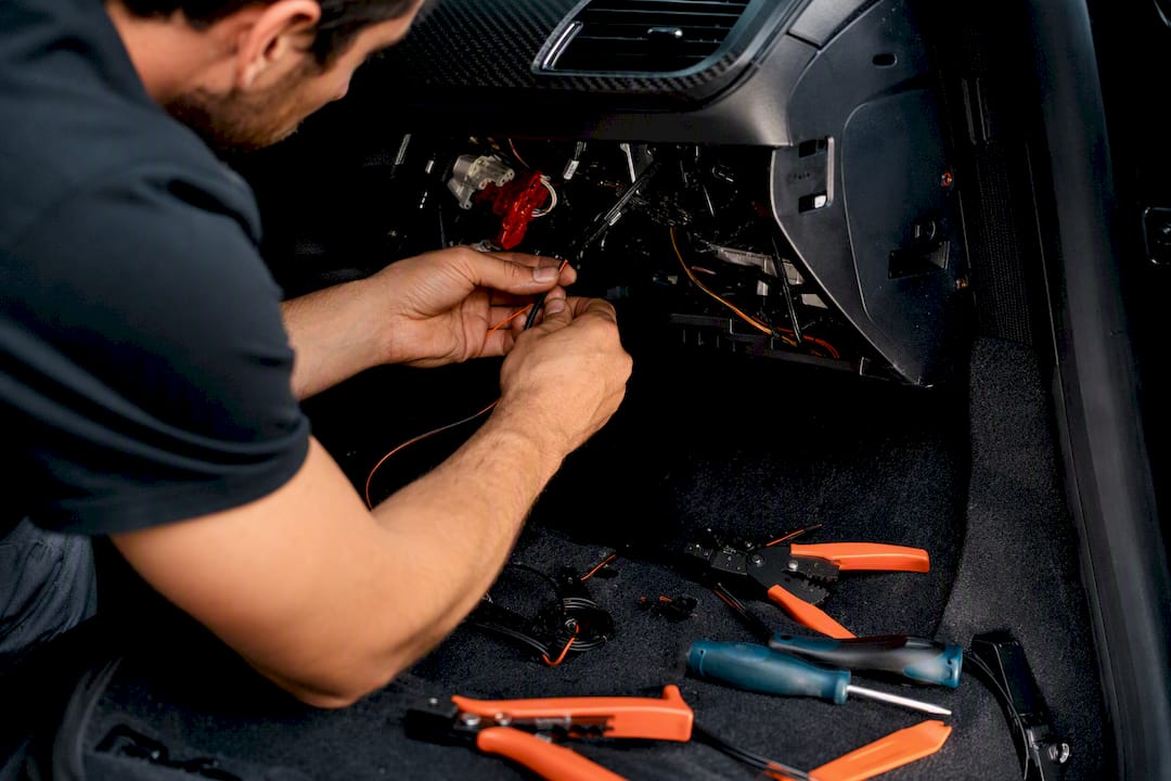
Behind that sits 24/7 monitoring and mobile app alerts that fire the moment something looks wrong, whether that’s an unauthorised movement or a tow-away attempt. If you’re weighing up whether to invest in marginal accuracy gains or in professional installation and monitoring, the monitoring wins every time for actual recovery outcomes.
What causes GPS errors: clocks, atmosphere and satellite orbits?
Three quiet sources of error sit underneath every GPS fix, and none of them show up on a spec sheet.
Clock errors come from the tiny discrepancies between the atomic clocks on satellites and the much cheaper clock inside your tracker’s receiver. GPS relies on nanosecond-level timing to calculate distance, so even a fraction of a millisecond of drift translates into metres of positioning error. Receivers correct for this mathematically, but it’s never perfect.
Atmospheric conditions distort signals as they pass through the ionosphere and troposphere. Charged particles in the upper atmosphere slow the signal down unpredictably, and that delay varies with time of day and solar activity. This is precisely the error that dual-frequency receivers are built to cancel out, since measuring two frequencies lets the device calculate the atmospheric delay directly rather than estimating it.
Satellite orbit errors happen because satellites don’t sit in perfectly stable, predictable orbits. Small deviations from their broadcast position (their ephemeris data) introduce a corresponding error into your fix. Ground control stations track and correct these deviations regularly, which is why keeping your tracker’s firmware and satellite data current genuinely helps.
Together these three sources make up the bulk of the User Range Error figure referenced in the SPS performance standard, and they’re the reason accuracy is described in probability terms (accurate 95% of the time) rather than as an absolute guarantee.
What do HDOP and PDOP mean for your tracker’s accuracy?
You’ll sometimes see HDOP or PDOP mentioned in tracker apps or technical reviews, and they’re worth understanding because they explain why the same device gives different accuracy readings on different days.
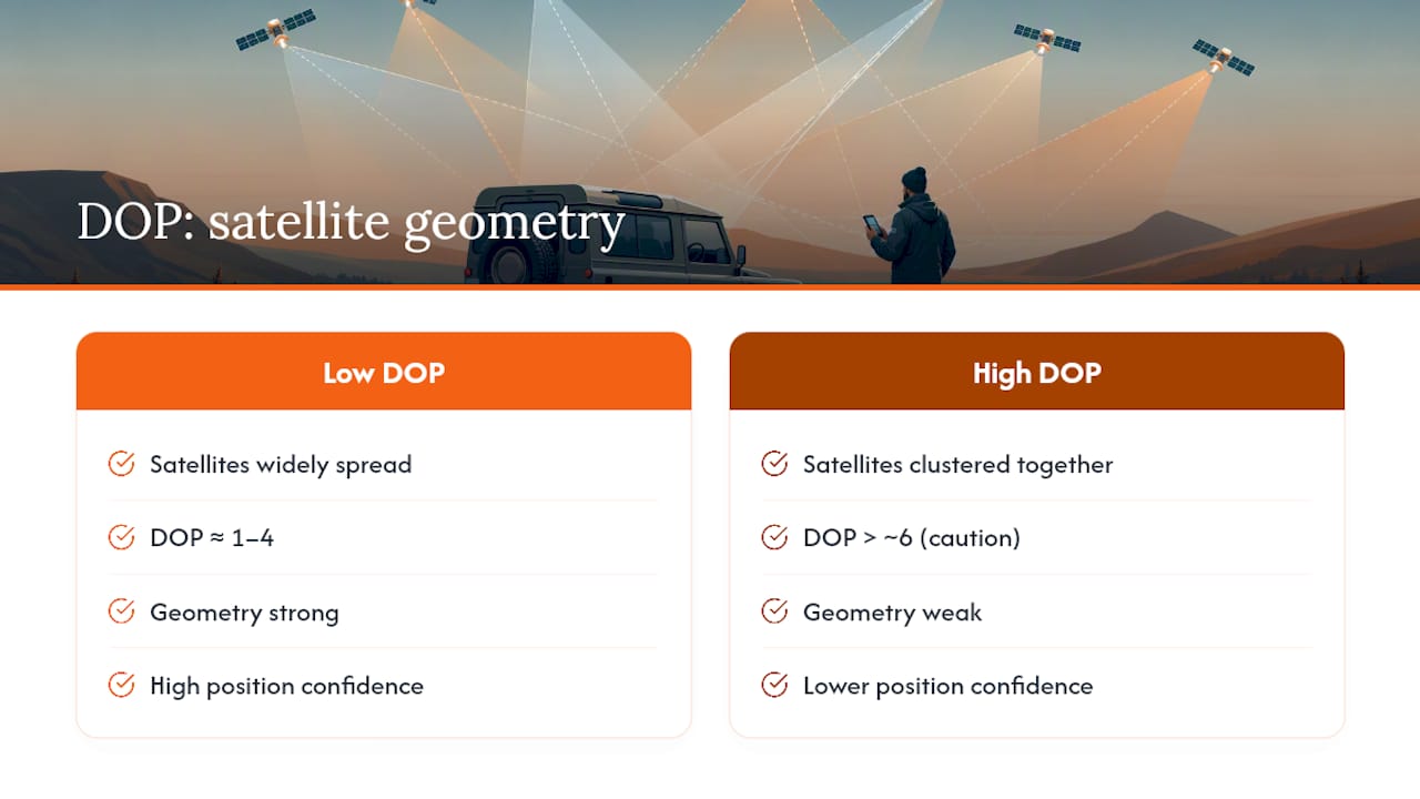
HDOP stands for Horizontal Dilution of Precision, and PDOP is Position Dilution of Precision (which includes vertical positioning too). Both are essentially a measure of how well-spread the satellites are across the sky at the moment your fix is calculated. When satellites are spread widely apart, the geometry is strong and DOP values are low, meaning higher confidence in the position. When satellites cluster together in one part of the sky, perhaps because buildings or hills block the rest, the geometry weakens and DOP values climb, meaning the same signal quality produces a less reliable fix.
A low DOP value (roughly 1 to 4) indicates excellent geometry. Values climbing past 6 or so suggest you should treat the reported position with more caution. This is precisely why urban canyons cause such trouble: it’s not just that signals get blocked, it’s that the satellites you can still see are often bunched together in a narrow strip of visible sky, which pushes DOP values up and precision down even when the raw signal strength looks fine.
How does GPS compare with GLONASS, Galileo and BeiDou?
GPS was the first global satellite navigation system and remains the most widely supported by consumer receivers, but it’s no longer the only option, and modern trackers rarely rely on it alone.
GLONASS, Russia’s equivalent system, offers similar baseline accuracy to GPS and is particularly useful at higher latitudes where GPS satellite geometry can be weaker. Galileo, the European Union’s system, was designed with modern dual-frequency capability built in from the start and often edges out GPS slightly in open-sky accuracy tests. BeiDou, China’s system, has expanded rapidly and now offers global coverage comparable to the other three.
None of these systems is dramatically more accurate than GPS on its own in good conditions; the real advantage comes from combining them. A multi-GNSS receiver that draws from GPS, GLONASS, Galileo and BeiDou simultaneously has access to far more satellites at any given moment, which strengthens geometry, lowers DOP values, and fills gaps where any single system might have a satellite blocked from view, according to Navipedia. This is exactly why multi-constellation support matters more in cities than open countryside. Where a GPS-only device might struggle with only four or five usable satellites behind tall buildings, a multi-GNSS receiver can often still see a dozen or more across all four systems combined.
Stop chasing metres, start trusting the fix
The obsession with shaving a tracker’s accuracy from 3 metres down to 1 metre is, frankly, solving the wrong problem for most owners. For personal and vehicle monitoring, the meaningful question isn’t “how tight is the fix” but “can I trust this fix consistently, and will I be alerted fast enough to act on it.”
Conventional advice fixates on spec sheets and marketing claims, when the real-world gap between advertised and delivered accuracy is usually down to placement, multi-GNSS support, and professional fitting rather than the chipset itself. A Thatcham-approved tracker installed properly, with a clean sky view and reliable monitoring behind it, will outperform a cheaper unit boasting sub-metre precision on a box that’s never tested against a Land Rover on a real UK street.
If you take one thing from this, prioritise the installation and the alerting, not the decimal point. Accuracy that’s good enough, paired with monitoring that never sleeps, beats theoretical precision every time it actually matters.
— Will
Sources
- GPS performances — GNSS & Satellite Systems (Navipedia, ESA/GSSC)
- How accurate are GPS tracking devices? — Logistimatics
- How accurate are GPS trackers in real life? — S3semi